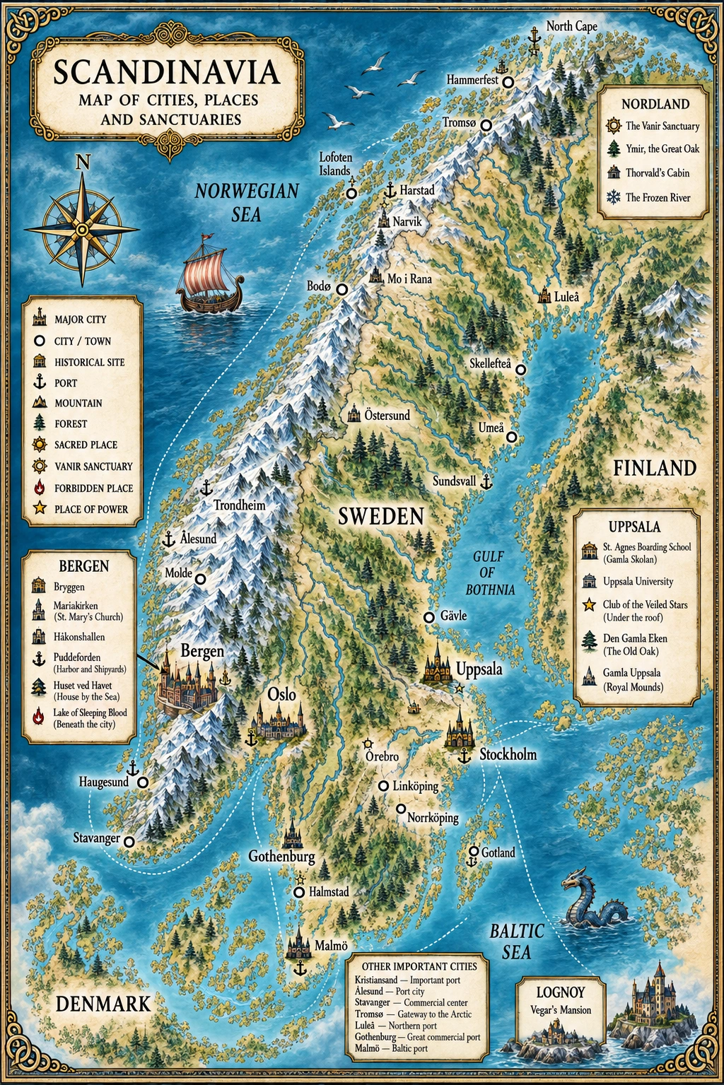
Norway in 1931 was a country caught between two worlds.
Electricity, automobiles, radio and railways were changing everyday life. Bergen and Trondheim were modern cities connected to international trade, while steamships carried passengers, mail and cargo along a coastline that had once made communication between communities painfully slow.
Yet beyond the cities, another Norway remained.
Farms stood between mountains and fjords. Fishing villages depended on the sea. Roads could deteriorate rapidly beyond the main routes, winter could isolate entire communities, and in much of the north the coastline remained a more dependable highway than the land.
The contrast was especially sharp in 1931.
The global economic crisis had reached Norway with force. Industrial production fell dramatically between 1930 and 1931, unemployment increased, rural communities struggled with falling prices and debt, and the country experienced one of the largest labour conflicts in its history. At the same time, modernization continued. Motor vehicles were becoming increasingly common, electricity was spreading through Norwegian homes, radio was beginning to transform communication, and the government continued improving roads and transport infrastructure.
For a twelve-year-old boy leaving Bergen and travelling north, these contradictions would have been visible everywhere.
A railway carriage could carry him across mountains that his great-grandparents would have needed days to cross. A coastal steamer could arrive according to a printed timetable. Then, hours later, he might find himself travelling through a landscape where a horse, a fishing boat or his own feet remained the most practical means of reaching the next valley.
This is the Norway through which Max’s journey begins.
BERGEN — WHERE THE JOURNEY BEGINS
For Max, Norway begins with salt water.
Bergen had always looked outward.
Protected by mountains yet open to the North Sea, the city had grown through commerce, fishing and maritime connections stretching far beyond Norway. Ships, warehouses, merchants and sailors were part of its identity. The harbour was less an edge of the city than its front door.
And nowhere was that history more visible than Bryggen.
The long line of narrow wooden buildings facing the harbour carried the physical memory of Bergen’s centuries as a trading centre. Behind their façades lay passages, storerooms and courtyards — a dense wooden world in which goods arriving by sea could disappear quickly from public view.
In The Wolf and the Snow, this is Max’s world before he understands what he is.
He runs through Bergen with his friends Axel and Ragnhild, explores the old harbour and enters a warehouse that appears abandoned. Inside, the children discover rifles and money. What begins as an adventure becomes a pursuit through Bryggen and eventually leads to the arrival of Thorvald, Max’s grandfather.
The setting matters.
Bergen was a plausible place for secrets carried by ships. It was a commercial port where sailors, businessmen, labourers, fishermen and travellers crossed paths every day. The sea connected the city not only with other Norwegian ports but with Britain, continental Europe and the wider Atlantic world.
By 1931, Bergen was also firmly connected to modern Norway. The Bergen Railway had linked the city with Oslo since 1909, one of the great engineering achievements of its generation.
Yet Max does not remain in this urban Norway.
Thorvald takes him away from the harbour, his family and everything familiar.
The north is waiting.
Explore more: Bergen in the 1930s — The City Behind Max’s Story →
LEAVING THE CITY
Railways, Roads and Travelling Through Norway in 1931
A modern map makes Norway look deceptively easy to cross.
In 1931, it was anything but.
Norway’s geography dictated how people travelled. Mountains divided communities. Fjords cut deeply into the land. Islands and narrow coastal settlements made straight roads impossible across large areas. A journey that appears simple on a map might require several different forms of transport.
Railways had transformed southern and central Norway, but the network was incomplete. Roads were expanding rapidly during the interwar period, and buses and automobiles were becoming familiar sights. Many roads, however, had originally been constructed for horses and lighter vehicles. The growing weight and speed of motor traffic forced the country to improve surfaces, curves and bridges. Snow clearance on important roads was also becoming increasingly mechanized during the 1920s and 1930s.
For long journeys, the traveller often moved in stages.
Train.
Steamship.
Motorcar or bus.
Local boat.
Horse or sleigh.
Then perhaps the final kilometres on foot.
The farther north Max and Thorvald travel, the more important this fragmented world becomes.
Distance in 1931 was measured not simply in kilometres, but in connections.
Miss a ship and the next stage of the journey might disappear with it.
TRONDHEIM — THE GATEWAY NORTH
Trondheim represented a threshold.
South of it lay Norway’s increasingly connected railway network. Beyond it, the geography of the journey changed.
The railway that would eventually become the Nordlandsbanen was still advancing northward. By 1929 trains had reached Grong. That was the end of the railway heading north in 1931. Mosjøen would not be reached until 1940, and Mo i Rana until 1942.
That single fact reveals something fundamental about northern Norway between the wars.
The north had not yet been conquered by rail.
From Trondheim onward, ships remained indispensable.
For travellers like Max and Thorvald, Trondheim therefore marks more than another city on the map. It is the point where the journey begins to belong increasingly to the coast.
And the coast had its own railway.
It was made of water.
THE COASTAL ROUTE
Norway’s Highway of Steam and Salt
By 1931, the Norwegian coastal steamer was already an institution.
The service that became Hurtigruten began in 1893, when Captain Richard With’s DS Vesteraalen sailed from Trondheim toward Hammerfest. Before regular coastal steamship connections, moving people, letters and goods through northern Norway could take weeks. The new service transformed that reality.
The route gradually expanded. Bergen became its southern terminus, while Kirkenes was incorporated in the far northeast. By the 1930s these ships were carrying far more than travellers.
They transported mail.
Fish.
Machinery.
Food.
Commercial goods.
News.
Families.
Officials.
Workers.
The ship entering a small harbour was therefore an event. It connected an isolated community with places hundreds of kilometres away.
For Max, a coastal voyage would have meant watching Norway change from the deck.
Cities receded.
Mountains moved closer to the sea.
The coast fractured into islands, channels and skerries. Small settlements appeared beneath immense slopes, sometimes gathered around little more than a quay, a church and a handful of houses.
The timetable offered modern precision.
The landscape offered none.
Storms, darkness, currents and winter weather still ruled the journey.
In 1931, Hurtigruten had yet to become the daily service it would be from 1936.
The north was connected.
It was still far away.
SANDNESSJØEN
Beneath the Seven Sisters
Sandnessjøen sits on the island of Alsta, facing one of the most distinctive landscapes on the Helgeland coast: the mountain range known as the Seven Sisters.
For centuries the settlement served as a local centre for trade, while its harbour connected the surrounding islands and coastal communities.
This is the scale of northern Norway that matters to Max’s journey.
Sandnessjøen was neither Bergen nor Trondheim. The sea was closer to everyday existence here. Boats were infrastructure. The harbour linked farms, islands and settlements scattered across a geography where mountains frequently made travel by land difficult.
For Max, every stop northward also strips away another layer of familiarity.
Bergen belongs to his childhood.
Helgeland belongs to Thorvald.
And Thorvald is taking him deeper into it.
MOSJØEN AND THE INTERIOR
Where the Railway Had Not Yet Arrived
Mosjøen stood at the head of Vefsnfjord, surrounded by mountains and connected historically to forestry, timber, trade and the movement of goods through the fjord.
It had received trading-town privileges in 1875 and developed into an important centre for Helgeland.
Yet its most revealing feature in 1931 was something it lacked.
A railway station.
The Nordland railway would not reach Mosjøen until 1940.
A traveller moving inland therefore entered a network of roads, local boats and older forms of transport.
Cars existed. Buses existed. Road construction was advancing. But a motor vehicle did not erase Norwegian geography.
Winter could turn a road into something entirely different.
Snow could make a sleigh more useful than wheels. A valley might provide the only practical route through the mountains. Local knowledge — knowing which road remained passable, where a boat could be found or when the weather was about to change — could matter as much as money.
That is the world Thorvald understands.
And Max must learn it.
MO I RANA
A Northern Town on the Edge of Change
Mo i Rana occupies a particularly interesting place in the Norway of 1931 because the town was already changing, yet had not become the industrial centre remembered from the post-war era.
Mo had long served as a market and trading centre. It became a ladested, or small privileged trading town, in the early 1920s. Mining had also begun altering the surrounding Rana district.
The Dunderland Iron Ore Company had developed iron-ore operations in the region and constructed its own railway for transporting ore between the mines and Gullsmedvik. Mining resumed between 1928 and 1931 — precisely the period in which Max arrives.
That makes 1931 Mo especially useful for the world of the novel.
It was neither an untouched wilderness nor the heavily industrialized Mo i Rana of later decades.
The future was visible, but unfinished.
Workers, merchants and mining activity belonged beside older patterns of fishing, farming and regional trade. Machinery and industrial ambition existed against a backdrop of immense mountains, forest and winter.
In The Wolf and the Snow, Mo i Rana is also where the hidden and ordinary worlds collide.
Max reaches the town after days in the wilderness with Skoll and searches for Ingrid, his relative, who runs an apothecary. Her profession suits the setting perfectly: a pharmacist belongs to modern science and commerce, while Ingrid secretly understands chemistry, runes and Seiðr.
The town becomes a refuge only briefly.
Hakon follows.
And when Max and Ingrid flee, the historical landscape and the fictional landscape deliberately begin to separate.
The real railway did not reach Mo i Rana until 1942.
The railway escape in the novel therefore belongs to its fictional geography rather than the literal transport network of 1931.
It is an important distinction — and an intentional reminder that this is historical fantasy, not documentary reconstruction.
FURTHER NORTH
Bodø and the Approach to the Arctic
Beyond Mo, distance becomes harsher.
The Arctic Circle lies just north of the Rana region. Beyond it, the seasonal extremes become increasingly pronounced: extraordinarily long summer days and winter darkness, coastal storms, mountain weather and vast distances between settlements.
Bodø offered another important harbour and another connection between sea and interior.
Yet even here the railway had not arrived.
The continuous railway link that modern travellers associate with Trondheim, Mo i Rana and Bodø belongs to a later Norway. In Max’s world, the coast remained the great artery north.
Steamships stitched together settlements that mountains kept apart.
That geography helps explain why Norwegian history has always been so intimately connected to the sea.
It also explains why leaving civilization in The Wolf and the Snow never requires Max to discover some completely unknown territory.
He simply has to move away from the harbour.
A few kilometres can be enough.
REAL NORWAY / FICTIONAL NORWAY
The Wolf and the Snow uses real geography, but it is not intended as a timetable from 1931.
Bergen, Trondheim, Sandnessjøen, Mosjøen, Mo i Rana and the landscapes of Nordland belong to the historical Norway in which the novel is rooted.
The distances are real.
The mountains are real.
The coastal dependence is real.
The incomplete railway network is real.
The mining activity around Rana is real.
So are the profound differences between urban Norway and isolated northern communities.
The novel then places another geography beneath that historical one.
Thorvald knows routes that do not appear on ordinary maps. Max learns to perceive the forest through the roots of the world. Ancient sanctuaries survive inside mountains. Yggdrasil is no longer simply a myth described in medieval texts but a living structure whose echoes remain accessible to certain descendants of the old gods.
There are also deliberate fictional adaptations of transport and geography. Most importantly, railway travel farther north than Grong belongs to the fictional framework when the story takes place in 1931. Historically, the Nordlandsbanen reached Mosjøen in 1940 and Mo i Rana in 1942.
That distinction matters because the supernatural world works best when the ordinary world beneath it remains recognizable.
Max can descend into the roots of Yggdrasil because this is fantasy.
He can meet Eira in a snow-covered forest because this is fantasy.
But the cold that can kill him, the enormous distances, the coastal steamers, the mining settlements and the isolation of Nordland belong to another source entirely.
History.
IN THE WOLF AND THE SNOW
Max begins his journey as a boy from Bergen.
That matters.
He understands streets, warehouses, friends, family and the harbour. He believes the world is larger than Bryggen, of course, but knowing that intellectually is different from experiencing it.
Thorvald changes the scale of his world.
The farther they travel, the smaller Max becomes against the landscape.
Railway carriages give way to ships. Harbours give way to roads. Roads lead toward forest. Eventually even roads disappear.
Then there is only snow.
A cabin.
A bow.
A grandfather.
A white dog named Skoll.
And a twelve-year-old boy discovering that the wilderness surrounding him is older, more dangerous and more alive than anything he knew in Bergen.
That transformation reflects something real about Norway in 1931.
Modernity had arrived, but it had arrived unevenly.
A person could hear a radio broadcast, board a train, travel on a scheduled steamship and then find himself, within the same journey, in a valley where weather and daylight still dictated the possibilities of human movement.
For Max, travelling north therefore means more than escaping the Broderskap.
With every kilometre, the modern world becomes thinner.
And beneath it, the older world begins to show through.
The world Thorvald remembers.
The world Eira inhabits.
The world beneath the world.
The roots are waiting there.